
UNIT 1: Planet Earth
1. This universe
In this unit we are going to learn about the Earth and its place in the Universe, how its rotation and revolution movements make the seasons and the day/night interaction possible and how we can represent, imperfectly, the Globe in a plane.
The origin of the Universe took place after a big explosion known as the Big Bang. This happened 13,700 millions years ago. Galaxies were formed, and inside the galaxies, planetary systems like the one we live in: the Solar System
The Galaxy where the solar system dwells is called The Milky Way
Questions about these videos
2. Movements of the Earth and their consequences
The movements of the Earth (and the tilt of the Earth's axis too) are the cause of several well known phenomena: the change of season, the transition from day to night, the solstice and the equinox.
The earth experiences two movements:
1. Rotation: The earth moves around the sun. It takes one year and six hours to complete one translation.
2. Revolution: the Earth rotates on its own axis. It takes one day to complete one revolution.
The translation and tilt of the earth's axis mean that the planet is, depending on the time of year, closer to the sun than others and that it receives more or less hours of sun. This determines the existence of seasons, solstices and equinoxes.
The seasons change according to a place on Earth that receives more or less hours of sun. This is crucial for the climate, for crops and for any form of life.
There are two solstices in a year: the winter one (the shortest day of the year and the longest night, in the boreal winter it is between December 21 or 22), and the summer one (day longest and shortest night, in the boreal summer it is between June 21 or 22)
The equinoxes are the days in which day and night last the same. There is an equinox in spring (March 21 or 22 in the northern hemisphere) and another in autumn (September 21 or 22).
The terrestrial revolution causes us to have day and night. Indirectly, this fact favors that it is not the same time all over the world at the same time, therefore, the Earth is divided into time zones.
Click here to know more about the time zones.
Midnight sun in Normway during summer
3. Thermal zones
The concept is very simple: since the sun rays strike the surface of the Earth at a different angle depending on the time of the year, the areas that receive these sun rays perpendicularly are hotter than those areas that receive sun rays at an acute angle. According to this, we have on Earth three Thermal Zones: Tropical (the hottest one), Temperate (moderate temperatures) and frigid or polar zones (the coldest ones).

4. Latitude and Longitude
If we want to locate any place in the world with absolute precision, we have to use a geographical grid. The lines that go from pole to pole are called meridians, and the horizontal lines that are perpendicular to the Earth's axis are called parallels. Taking the Equator as a reference, if we move North or South (always in degrees, since it's an angular distance) we will talk about latitude. Taking the Greenwich meridian as a reference, if we move East or West, we will talk about longitude. The combination of the two measures will give us a precise point on Earth.
You can test your skills about finding a place on the map using geographical coordinates here. Be the fastest and enter the hall of fame!
5. Projections
If we want to represent the globe in a flat map, we have to make a projection, or what is the same, to reflect the seas and continents in the plane. This is a real problem for cartographers, because it is literally impossible to reflect the sphere in a rectangular plane and not to have the continents somehow deformed. Split an old ball in half and try to flatten it, you will understand what I mean.
In a projection, if the shape of the continents is real, their size and distance between them will be deformed, and vice versa. There are hundreds of different types of projections, because none is perfect. The most popular are the cylindrical, the conic and the azimuthal.
Click here to see how the maps are rigged, as it is impossible to project the continents of the earth, which is a sphere, onto a plane and not change the size, distance or angle of those continents.
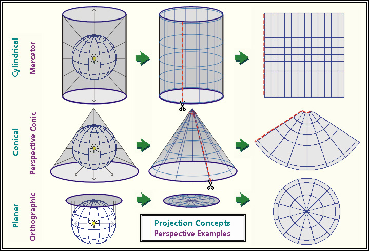
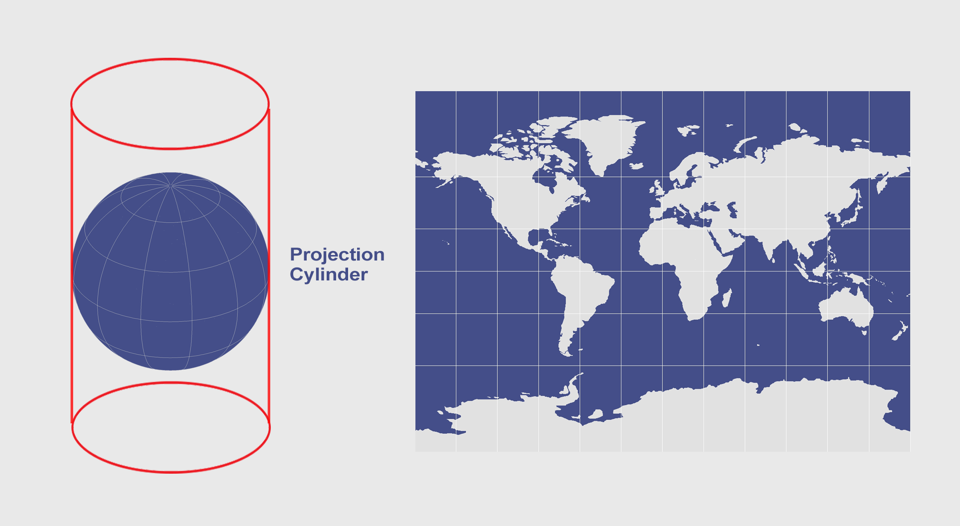
Cylindrical projection
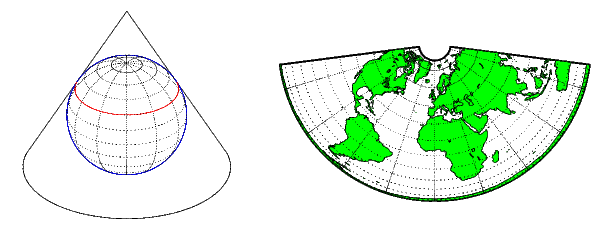
Conical projection
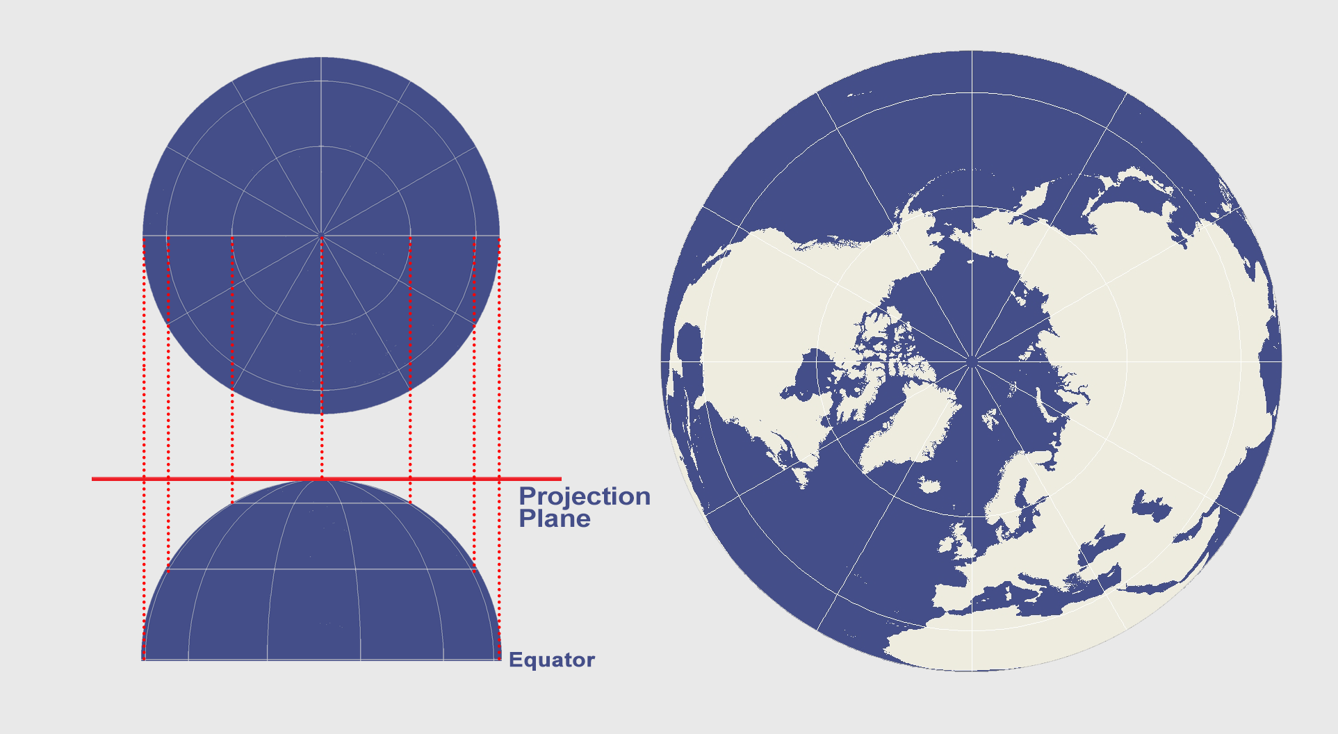
Azimuthal projection
If you want to see some other projections of the Earth, click here
Test
Click here to take the test.