
Unit 6: Spain's physical environment and bioclimates


1. Spanish relief
In Spain we may find all kind of relief accidents: mountain ranges, peninsulas, capes, gulfs, etc. We will learn the most important ones and how to locate them in the map throughout this lesson

Click on the map to practice Spain's relief in an interactive game
2. Spanish political map
Spain is divided into 17 Autonomous Communities and two Autonomous Cities. Each Community contains a variable number of provinces. Some, like Madrid, La Rioja or Murcia, only have one province. Others, such as Castilla-León or Andalusia, have 9 and 8 provinces respectively.

Spain's Autonomous Communities and their flags. To practice the Communities, click here. To practice the flags, click here.

Provinces of Spain. Although they are not represented in this map, we shouldn't forget there are two autonomus cities in the north of Africa: Ceuta and Melilla. To practice the provinces, click here.
3. Waters
2.1) Marine waters: The Atlantic ocean is located to the North and West of the Iberian Peninsula (the sea in the north is called Cantabrian sea) and the Mediterranean sea is located to the south and east of the Peninsula.
2.2) Rivers: There are many rivers in Spain, but most of them are narrow and don't bring too much water. The Ebro river is the one that carries the largest amount of water, and also the longest one in Spain. Tagus river is longer than Ebro, but part of its course runs through Portugal.

Click on the map to practice Spain's rivers in an interactive game

Ruidera lagoons, Ciudad Real

Sanabria lake, Zamora
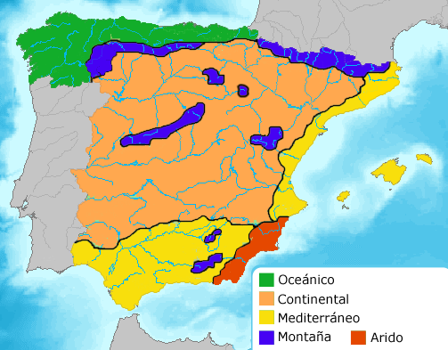
4. Spain's bioclimates environments
4.1) Oceanic bioclimate
Where: North and north-west of the Peninsula
Temperature: Winters are mild and summers are cool, so it's never too cold or too hot.
Precipitation: High levels and regular throughout the year.
Vegetation: Deciduous trees (beeches, oaks, chestnuts)
Click the map to enlarge


Climate graph and landscape of Llanes, Asturias
4.2) Mediterranean bioclimate
Where: Inland area of the Peninsula to the south of the oceanic bioclimate, the area along the Mediterranean coast, the Balearic islands, Ceuta and Melilla
Tempetarure:
-Along the coast: mild winters and hot summers.
-Inland: Cold winters and hot summers
Precipitation: Moderate and irregular. It is very dry in the summer.
Vegetation: Evergreen forest (perennial trees: holm oaks, cork oak, olive tree...)


Climate graph and landscape of Ubeda, Jaén: the famous Ubeda Hills full of olive trees
4.3) Subtropical biocalimate:
Where: Canary Islands.
Temperature: little contrast throughout the year. Warm winters and hot summers
Precipitation: Scarce. Very dry summers.
Vegetation: Autochthonous species: Dragon treee, palms, canary pines. Scrubland in high, cold areas

Puerto de la Cruz, Tenerife

Canary Palm tree

Canary Dragon Tree

Euphorbia Balsamifera in a Canary landscape. This typical shrub grows near the sea level or at a low altitude.
4.4) Alpine bioclimate
Where: Mountain ranges above 1000 m
Temperature: Low average. Very cold winters.
Precipitation: High (lower at heights above 3000 m)
Vegetation: It depends on the zoning, as we learnt in Unit 5
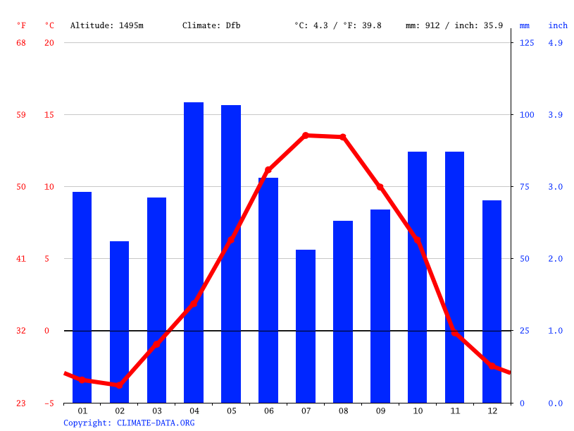

Cerler, Huesca
Voluntary work: Human impact on the environment. Click here for directions