
Unit 4:
The Climate and bioclimatic zones
1. The atmosphere and its changes
The atmosphere is the layer of gases that surrounds the earth. It is important because, without it, human life would be impossible.
The gases that compose it are, above all, nitrogen and oxygen, and to a lesser extent, other gases such as argon, neon, carbon dioxide, etc.
The atmosphere is essential because if it did not exist:
* The average temperature of the Earth would be -22ºC.
* We could not breathe.
* The solar radiation would be too high to resist it.
* The meteoroids would not transform into shooting stars and would reach the Earth in the form of a rock, with the consequent danger.

Composition of the atmosphere
With atmosphere and without atmosphere


Crater created by a meteor. Nunavik, northern Quebec, Canada.

Layers of the Atmosphere
Exosphere: The gases are dispersed little by little, until the composition is similar to that of outer space.
Thermosphere or Ionosphere: In this layer, the ionized gases reach very high temperatures. Space shuttles circulate through this layer. It is also where aurora borealis is formed.
Mesosphere: It protects Earth's surface from being hit by most meteoroids.
Stratosphere: It contains the ozone layer, which absorbs ultraviolet rays from the sun and protects us from dangers such as skin cancer or the ruin of crops.
Troposphere: It is in contact with the earth's surface, therefore it is in which all of us live. In it all climatic and meteorological phenomena occur.
Difference between weather and climate:
Among the layers of the atmosphere, the one that interests us most is the troposphere, which is where climatic phenomena occur. But what is the difference between weather and climate?
Weather: It is the state of the atmosphere in a specific place and time. For example, today, in Alcalá, the weather can be rainy, cold, sunny, etc. while the weather in Buenos Aires can be hot, dry, windy, etc. Weather is represented on a weather map.
Climate: It is the average state of the atmosphere in a specific place during a minimum period of 30 years. That is, it is as if we measure weather every day for 30 years and then we calculate the average. The climate is represented in a climograph.
This is weather

This is climate

This is a climate graph. The red curve shows the average temperature through the months of the year. The blue bars show the precipitations.


2. Elements of climate (I).
Temperature and precipitation
The elements that determine the climate are four:
*Temperature
*Precipitation
*Atmospheric pressure
*Wind
All of them are influenced by the following climate factors:
*Latitude
*Altitude
*Distance from the sea
Temperature measures the amount of heat in the air. To do this, we use a thermometer, and as a unit of heat, we use the centigrade or Celsius degrees (ºC). In some countries, such as the United States, they use Fahrenheit degrees (ºF).
How climate factors influence temperature:
Latitude: We have already studied in unit one that there are different thermal zones on earth. The further we get away from the equator (that is, the higher the latitude is) the colder it is.
Altitude: The higher we are compared to sea level, the colder it will be. The temperature drops, more or less, 0.5 ºC every 100 meters of altitude. With less oxygen in the heights, the heat is not preserved.
Distance from the sea: Liquids take a long time both to warm up and to cool down, while in solids the opposite occurs. Therefore, seawater changes temperature very slowly, so near the coast temperatures are softer than in the interior.
The formula to convert Celsius to Fahrenheit degrees is as follows:
T(°C) = (T(°F) - 32) × 5/9

The farther we are from the Equator, the colder it is. In other words, the higher the latitude is, the colder it is. That happens because the sun rays strike the tropical zone nearly perpendicularly.

The higher we climb the mountain, the colder it is. That is because in the heights there is less oxygen than at sea level. Oxygen can preserve heat, but if there is little oxygen, obviously there is little heat.
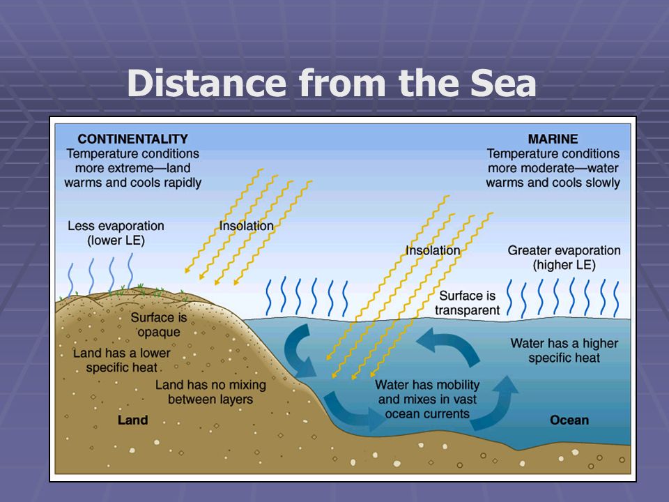
Since sea temperature changes very slowly, temperature by the coast is generally mild. Although there are other factors that can influence on it, like the marine currents.
Precipitation: It is the water that falls on the earth. It can fall in the form of rain, snow or hail. Precipitation is measured with a rain gauge and the unit used is millimeter (mm) or liter per square meter (l / m2).
How do climatic factors influence precipitation?
One thing to keep in mind: hot air is able to absorb a lot of moisture and tends to rise. Cold air acts on the contrary: it tends to descend and is not able to contain moisture. Therefore: when humid air cools, precipitation occurs.
Latitude: Where it rains most is in the tropical and equatorial zones. This is because the air is hot (receives a lot of sun) and tends to ascend with a lot of evaporated humidity. When that air is very high, it condenses forming clouds, it cools and it rains. After this everything starts again, you know how the water cycle works.
Altitude: It precipitates more in high places, for that reason, some mountains are always snowed, even in summer. The reason is the same as before: in the heights, the air cools and can not contain the humidity.
Distance from the sea: There is more rainfall near the sea, because it provides humidity to the air constantly.


Rain gauge
Some interesting facts about temperature and precipitation
Atacama desert, Chile
Driest place on Earth


Yakutsk, Russia


3. Elements of climate (II).
Atmospheric pressure and wind
Atmospheric pressure: It is the weight of the air over a certain point. Although they are not visible to the naked eye, there are layers of air. In the place where more layers of air accumulate, the atmospheric pressure will be higher, and vice versa.
The average atmospheric pressure is measured at sea level, and is 1013.5 millibars (the millibar, or mb, is the unit of pressure, although sometimes the hectopascal [hPa] can be also used, but there is no problem, since they are equivalent). If in a specific place the 1013.5 mb is exceeded, an anticyclone (high pressure zone) is produced, if, on the contrary, if it is below 1013.5 mb, a depression occurs (low pressure zone, also called cyclons) . To measure the pressure, we have to use a barometer.
Why does the atmospheric pressure change?
Altitude: The higher a place is, the lower the atmospheric pressure, and vice versa. This is easy to understand: if we are at sea level, there will be more layers of air above us (higher pressure), but if we are on top of a mountain, there will be less layers of air above us (lower pressure).
Air temperature: The hot air is very light and absorbs a lot of humidity. It tends to ascend as if it were a balloon, but the higher it rises, the colder it becomes. This air, which is now cold, can not contain the humidity and then precipitation occurs. This happens when there is low pressure and it is what we commonly call a cyclon or depression (borrasca).
On the other hand, cold air is heavier and drier, and tends to descend to the ground. This abundance of heavy and dry air in a specific place produces high pressure, and it is what we commonly call anticyclone.

What would be experiencing the guy at the top of the mountain, an anticyclone or a depression? Will it precipitate?


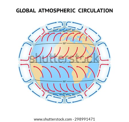
Due to the global atmospheric circulation, there are areas of permanent low pressure, like the equator, and areas of permanent high pressures, like the tropics.
A: Anticyclone or high pressure.
B: Cyclone or low pressure.
_____: Isobaras. They delimit areas that have the same atmospheric pressure.
Wind: is the movement of air. Its speed is measured with an anemometer. The wind always moves from high pressure areas to low pressure areas. The higher the difference between pressures, the higher the wind speed.
There are winds that are constantly blowing in certain areas of the planet, such as the trade winds, the westerly winds or the polar winds.


Anemometer
4. Climate, vegetation and bioclimates
Climate: We have said before that climate is the average weather in a certain place for a minimum period of 30 years. As we have seen previously, the temperature, the precipitations, the atmospheric pressure and the wind are not equal in all the parts of the world, and for that reason different climates exist.
We already saw in unit 1 that there are three very defined climatic zones on the earth: torrid, temperate and frigid.
Vegetation: It is the set of all the plants of the biosphere. The vegetation is classified into three groups:
1) Forest: formed by trees, which are plants with well-defined branches and branches.
2) Scrublands: these are plants that do not have a trunk. The branches grow at ground level, such as thyme or garrigue.
3) Grasslands: consists of grass and pastures.
The vegetation type of an area depends on several factors:
* type of weather
* type of soil
* amount of light that reaches this floor
*humidity
*wind
*temperature
*etc.
Bioclimate: It is the relationship between climate and living beings, specially vegetation. Each climate zone corresponds to a characteristic vegetation, which is why we also speak of torrid, temperate and frigid bioclimates. But all of this will learnt in the next unit.


Forest

Scrublands

Grasslands
Voluntary work:
These are the links for the Youtube videos about the atmosphere.
English: click here
Spanish: click here
Worksheet: click here